This is an old revision of the document!
Table of Contents
Online Help > AlpineQuest 2.x > Settings
User settings
These settings must be saved in a text file called “user_settings.conf” inside the application folder.
![]() Be sure to use the last version so all settings are available.
Be sure to use the last version so all settings are available.
![]() You must restart the application after changing any of these settings.
You must restart the application after changing any of these settings.
![]() Setting names don't contain white spaces.
Setting names don't contain white spaces.
List of user settings
| Name | Type | Default value | Preview |
|---|---|---|---|
| Core | |||
core.logs.verbose | Boolean | 0 / false | |
| Activate the verbose mode so the application displays more information in the log files. | |||
core.locale | [ ar, bg, de, en, es, fr, it, ko, lt, pt, nl, ro, ru, sk, tr, uk, zh ] | empty | |
| Force a different language other than the one of the device. | |||
core.custom_location_printer | [ grid, xy, d, dm, dms ],String | empty | |
| Define a custom coordinate format. The first part is the display format, the second part is the OGC WKT of the projection (for example something like this). | |||
core.bearing_decimals | Integer | 2 | 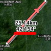 |
| Define the maximum number of decimals to use when displaying bearing units. | |||
core.pictures.format | String | yyyy-MM-dd_HH-mm-ss | |
| Define how to name pictures taken from the application, for example when creating picture waypoints (see accepted patterns here). | |||
core.screen.orientation | [PORTRAIT, LANDSCAPE] | empty | |
| Force a particular screen orientation. | |||
core.submenu.force_exit_button | Boolean | 0 / false | 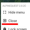 |
| Display an exit button in the main menu on all devices. | |||
core.submenu.display_workspaces_chooser | Boolean | 1 / true | |
| Display a chooser to switch workspace in the main sub-menu (only when at least one alternate workspace has been created). | |||
core.menu.display_help_buttons | Boolean | 1 / true | |
| Display help buttons in the menus. | |||
core.submenu.disable_long_press | Boolean | 0 / false | |
| Disable long-press action (select the top menu item) for the main menu. | |||
core.behavior.finish_on_external_map | Boolean | 0 / false | |
Close the application when selecting an external mapping application from the “Open with…” action (including OpenStreetMap, Google, Yandex and Navigation choices). When using “Other application…”, the application won't be closed as it has no way to know what is the chosen application. |
|||
| Main map | |||
map.infobox.text_color | String | #212121 | 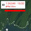 |
| Define the display color of the texts displayed in the information boxes (see accepted colors here). | |||
map.infobox.text_bold | Boolean | 0 / false | |
| Display texts in the information boxes in bold. | |||
map.coordinates.main.color | String | #000000 | |
| Define the display color of the main coordinate format and grid (see accepted colors here). | |||
map.coordinates.alternative.color | String | #0000FF | |
| Define the display color of the alternative coordinate format and grid (see accepted colors here). | |||
map.canvas.heading_arrow_size_factor | Float | 1.0 | |
| Display size factor for the heading arrow. | |||
map.canvas.heading_arrow_alpha | Float [0.0 - 1.0] | 1.0 | |
Display transparency for the heading arrow (from “0.0” completely transparent to “1.0” completely opaque). |
|||
map.canvas.heading_fov_size_factor | Float | 1.0 | |
| Display size factor for the heading field-of-view. | |||
map.coordinates.share_crs | String | EPSG:4326 | |
EPSG code of the coordinate reference system (CRS) to use when sharing a coordinate using the “Share” action. By default, the application uses the GPS coordinate system (code “EPSG:4326”) |
|||
map.coordinates.share_provider | String | empty | |
URL of a mapping website to use in the “Share” action text message. The following variables are available: “{$longitude}”, “{$latitude}” and “{$zoom}”. The default URL is “https://google.com/maps/place/{$latitude},{$longitude}”. To display an OpenStreetMap URL, use “https://www.openstreetmap.org/#map={$zoom}/{$latitude}/{$longitude}”, for Yandex Maps (less details) use “https://yandex.ru/maps/?ll={$longitude},{$latitude}&z={$zoom}&pt={$longitude},{$latitude}”, for Yandex Maps (more details) use “https://yandex.ru/maps/?ll={$longitude}%2C{$latitude}&z=15&mode=whatshere&whatshere%5Bpoint%5D={$longitude}%2C{$latitude}&whatshere%5Bzoom%5D=15”, for Here Maps use “https://wego.here.com/?map={$latitude},{$longitude},{$zoom}”. |
|||
map.coordinates.openwith_provider.osm | String | empty | |
URL of the website to use when selecting the “Open with… OpenStreetMap Maps” action. The default URL is “https://www.openstreetmap.org/#map={$zoom}/{$latitude}/{$longitude}”. |
|||
map.coordinates.openwith_provider.google | String | empty | |
URL of the website to use when selecting the “Open with… Google Maps” action. The default URL is “https://google.com/maps/place/{$latitude},{$longitude}/@{$latitude},{$longitude},{$zoom}z”. |
|||
map.coordinates.openwith_provider.yandex | String | empty | |
URL of the website to use when selecting the “Open with… Yandex Maps” action. The default URL is “https://yandex.ru/maps/?ll={$longitude}%2C{$latitude}&z={$zoom}&mode=whatshere&whatshere%5Bpoint%5D={$longitude}%2C{$latitude}&whatshere%5Bzoom%5D={$zoom}”. |
|||
map.coordinates.openwith_provider.here | String | empty | |
URL of the website to use when selecting the “Open with… Here Maps” action. The default URL is “https://wego.here.com/?map={$latitude},{$longitude},{$zoom}”. |
|||
map.buttons.offset_y | Integer | 0 | |
| Y offset (in pixel) for the display of zoom buttons. | |||
map.canvas.popup_comment_size | Float | 12.0 | 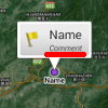 |
| Text size (in sp) of popup comments when clicking on a displayed landmark. | |||
map.canvas.tiles_bitmap_config | [RGB_565, ARGB_8888] | RGB_565 | |
| Image quality (bitmap configuration) used for the map canvas tiles. ARGB_8888 has a better display quality but uses more memory (4 bytes instead of 2 for RGB_565). | |||
map.canvas.smooth_end_move | Boolean | 1 / true | |
| Define if the map continues to move a little after ending sliding it. | |||
map.canvas.display_copyrights | Boolean | 1 / true | |
| Display maps data copyright notice on the map. | |||
map.canvas.display_center_icon | Boolean | 1 / true | |
| Display the screen center icon. | |||
map.canvas.center_point.radius | Integer | 5 | |
| Radius (in dp) of the screen center icon. | |||
map.canvas.display_osm_zoom_id | Boolean | 0 / false | 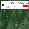 |
| Display the OSM/Google zoom index id in the map scale information box. | |||
map.scales.default_overscaling_levels | Integer | 4 | |
| After reaching the maximum zoom level of a map, number of possible additional “+” zoom button presses, allowing to artificially increase the display scale of the last zoom level. | |||
| Maps | |||
maps.debug | Boolean | 0 / false | |
| Activate the debug mode for maps: increases logs for maps and displays map tile bounds and coordinates on the screen. | |||
maps.submenu.disable_long_press | Boolean | 0 / false | |
| Disable long-press action (select the top menu item) for the “Maps” menu. | |||
maps.explorer.cells_layer_alpha | Float [0.1 - 0.9] | 0.5 | |
| Alpha value of the white layer displayed over the previews in the Maps Explorer. | |||
maps.features.favorites.ask_if_outofbounds | Boolean | 0 / false | |
| When selecting a favorite map that doesn't cover the currently displayed area, ask the user to move to a covered area. | |||
maps.features.offlinemaps.explorer.display_root | Boolean | 0 / false | 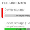 |
| Display an entry allowing to select the device's root folder in the menu drawer of the Maps Explorer. | |||
maps.features.offlinemaps.coverage_autoload | Boolean | 1 / true | |
| When moving the map, automatically select another file-based map (from the same folder) if the current map doesn't cover the current location anymore. | |||
maps.features.offlinemaps.zoom_buttons_autoload | Boolean | 1 / true | |
| When using +/- zoom buttons, automatically select another file-based map (from the same folder) if the current map doesn't cover the current scale anymore. | |||
maps.features.offlinemaps.overscaling_levels | Integer | 4 | |
| Number of additional times the “+” zoom button can be pressed after reaching the last level of details of the current map, virtually increasing even more the zoom. | |||
maps.features.offlinemaps.underscaling_levels | Integer | 2 | |
| Number of additional times the “-” zoom button can be pressed after reaching the first level of details of the current map, virtually reducing even more the zoom. | |||
maps.features.offlinemaps.formats.aqm.create_index | Boolean | 1 / true | |
| Create index files for AQM maps in order to speed-up loading. | |||
maps.features.offlinemaps.formats.ozf.crop_to_mmp | Boolean | 1 / true | |
Crop displayed .ozf2 and .ozfx3 maps along the “Moving Map Parameter” definitions of the .map file. |
|||
maps.features.areadownloader.max_queue_size | Integer | 100000 | |
| Maximum number of tiles allowed to be downloaded at once in the store area tool (large values can hang or crash the application). | |||
maps.features.elevations.display_status | Boolean | 1 / true | |
| Display the status of downloading DEM elevation data chunks on the map. | |||
maps.features.elevations.hillshade.exageration | Float | 1.2 | |
| Exaggeration factor used when generating built-in hillshade layer from local DEM elevation data. | |||
maps.features.elevations.hillshade.light_source_angle | Integer [0 - 360] | 45 | |
| Light source azimuth (in degrees) used when generating built-in hillshade layer from local DEM elevation data. | |||
maps.features.onlinemaps.status.display_offline | Boolean | 1 / true | |
| Display a message over missing parts of on-demand maps when there is currently no network. | |||
maps.features.onlinemaps.status.display_unavailable | Boolean | 1 / true | |
| Display a message over missing parts of on-demand maps that are not available on the server. | |||
| Placemarks | |||
landmarks.submenu.disable_long_press | Boolean | 0 / false | |
| Disable long-press action (select the top menu item) for the “Placemarks” menu. | |||
landmarks.painter.center_labels_size_factor | Float | 1.0 | |
| Display size factor for texts displayed above and below the screen center icon. | |||
landmarks.painter.labels_factor | Float | 1.0 | |
| Display size factor for landmark labels displayed on the map. | |||
landmarks.painter.paths_factor | Float | 1.0 | |
| Display size factor for paths displayed on the map. | |||
landmarks.painter.points_factor | Float | 1.0 | |
| Display size factor for points displayed on the map. | |||
landmarks.painter.icons_factor | Float | 1.0 | |
| Display size factor for landmark icons displayed on the map. | |||
landmarks.painter.picture_heading | Boolean | 1 / true | |
| Display field of view direction of pictures on the map when available. | |||
landmarks.painter.max_labels_chars | Integer | 25 | |
| Maximum number of characters for names of landmarks displayed on the map. | |||
landmarks.selector.max_multi_items | Integer | 25 | |
| Maximum of displayed sub-items in popups displayed when selecting landmarks on the map. | |||
landmarks.selector.display_elevation | Boolean | 1 / true | |
| Display the elevation (if available) in the popups displayed when selecting landmarks on the map. | |||
landmarks.selector.display_date | Boolean | 0 / false | |
| Display the data (if available) in the popups displayed when selecting landmarks on the map. | |||
landmarks.proximity.color | String | #A52A2A | 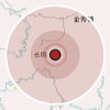 |
| Color used to draw proximity alerts (see accepted colors here). | |||
landmarks.targeter.max_save_targets | Integer | 1000 | |
| Number of recently targeted locations to keep in the unsorted landmarks targets set. Set to 0 to not save targeted locations. | |||
landmarks.targeter.display_target_line | Boolean | 1 / true | |
| Draw a line between the screen center icon and the currently targeted location. | |||
landmarks.symbols.color.tourism | String | #AF17A6 | |
| Color used to draw symbols of the “Tourism” category (see accepted colors here). | |||
landmarks.symbols.color.natural | String | #5D7C00 | |
| Color used to draw symbols of the “Natural” category (see accepted colors here). | |||
landmarks.symbols.color.man_made | String | #5D6872 | |
| Color used to draw symbols of the “Man made” category (see accepted colors here). | |||
landmarks.symbols.color.accommodation | String | #348AC6 | |
| Color used to draw symbols of the “Accommodation” category (see accepted colors here). | |||
landmarks.symbols.color.food | String | #734A08 | |
| Color used to draw symbols of the “Food” category (see accepted colors here). | |||
landmarks.symbols.color.amenities | String | #9B550A | |
| Color used to draw symbols of the “Amenities” category (see accepted colors here). | |||
landmarks.symbols.color.sport | String | #39AC39 | |
| Color used to draw symbols of the “Sport” category (see accepted colors here). | |||
landmarks.symbols.color.transportation | String | #11B6E5 | |
| Color used to draw symbols of the “Transportation” category (see accepted colors here). | |||
landmarks.symbols.color.water | String | #005CDA | |
| Color used to draw symbols of the “Water” category (see accepted colors here). | |||
landmarks.symbols.color.power | String | #FF8F21 | |
| Color used to draw symbols of the “Power” category (see accepted colors here). | |||
landmarks.symbols.color.shopping | String | #AC39AC | |
| Color used to draw symbols of the “Shopping” category (see accepted colors here). | |||
landmarks.symbols.color.worship | String | #000000 | |
| Color used to draw symbols of the “Worship” category (see accepted colors here). | |||
landmarks.symbols.color.health | String | #DA0092 | |
| Color used to draw symbols of the “Health” category (see accepted colors here). | |||
landmarks.explorer.display_full_bearing | Boolean | 0 / false | 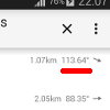 |
| Display the bearing value to waypoint values in addition of the direction arrow in the Landmarks Explorer. | |||
landmarks.details.expand_file_section | Boolean | 0 / false | |
| In the details view of a landmark, display the “File” section opened by default. | |||
landmarks.creator.sets.ask_for_names | Boolean | 1 / true | |
| Ask for waypoint names when creating sets of waypoints. | |||
landmarks.creator.waypoints.force_on_gps | Boolean | 0 / false | |
| Create new waypoints on the current GPS location (if available) instead of the current screen center location. | |||
landmarks.features.offlinelandmarks.explorer.display_root | Boolean | 0 / false | 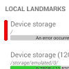 |
| Display an entry allowing to select the device's root folder in the menu drawer of the Landmarks Explorer. | |||
landmarks.features.offlinelandmarks.open_file_auto_choice | [ 0, 1, 2 ] | 0 | 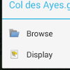 |
Action to make when opening a landmarks file to import (.gpx, .kml, etc.) from an external file manager: 0 (ask the user), 1 (browse content), 2 (display content). |
|||
landmarks.features.offlinelandmarks.formats.gpx.export_wgs84_elevations | Boolean | 0 / false | |
| Use the WGS84 elevations instead of the EGM96 elevations in exported GPX files. | |||
landmarks.features.offlinelandmarks.formats.gpx.export_geoidheight | Boolean | 0 / false | |
Write the “geoidheight” tag (see specification here) in exported GPX files (the geoid height is the difference in meters between the EGM96 elevation and the WGS84 elevation). |
|||
landmarks.features.offlinelandmarks.formats.gpx.export_pictures | Boolean | 0 / false | |
Write “picture” tags containing the path of pictures associated with waypoints in exported GPX files. |
|||
landmarks.preprocessing.type | [0, 1, 2] | 2 | |
Pre-processing type applied to tracks upon loading: 0 (no pre-processing), 1 (only check erroneous time values), 2 (check erroneous times and remove inaccurate points). The pre-processing setting must also be checked in the regular application preferences. |
|||
landmarks.preprocessing.max_passes | Integer | 10 | |
| Maximum iterations to make when removing inaccurate points. | |||
| Positioning | |||
geolocation.submenu.disable_long_press | Boolean | 0 / false | |
| Disable long-press action (select the top menu item) for the “Positioning” menu. | |||
geolocation.localisation.painter.color_accurate | String | #0064FF | |
| Color used to draw the current location when accurate (see accepted colors here). | |||
geolocation.localisation.painter.color_inaccurate | String | #E30000 | |
| Color used to draw the current location when not accurate (see accepted colors here). | |||
geolocation.localisation.egm96_adjustment.gps | Boolean | 1 / true | |
Adjust provided elevations to Geoid elevations using the EGM96 model for location provider “gps”. |
|||
geolocation.localisation.egm96_adjustment.network | Boolean | 0 / false | |
Adjust provided elevations to Geoid elevations using the EGM96 model for location provider “network”. |
|||
geolocation.localisation.egm96_adjustment.passive | Boolean | 0 / false | |
Adjust provided elevations to Geoid elevations using the EGM96 model for location provider “passive”. |
|||
geolocation.course_line_width | Float | 2.0 | |
| Width (in dp) of the displayed GPS course line. | |||
geolocation.course_line_color | String | #000000 | |
| Color of the displayed GPS course line (see accepted colors here). | |||
geolocation.course_line_dashes | String | empty | |
Dashed definition of the displayed GPS course line (first number is length of drawn part, next number length of transparent part, etc.). Use “N” for no dashes, or “A” for arrow dashes. |
|||
geolocation.course_line_style | String | A | |
Use “A” for displaying arrows. |
|||
geolocation.localisation.relock_delay_ms | Integer | 10000 | |
| Time (in milliseconds) after which to re-lock the GPS location if this option is checked in the main settings. | |||
geolocation.localisation.display_distance_line_eta | Boolean | 1 / true | |
| Display the ETA when moving the map center away from the current GPS location. | |||
geolocation.localisation.display_distance_line_bearing | Boolean | 0 / false | |
| Display the bearing when moving the map center away from the current GPS location. | |||
| Orientation | |||
orientation.submenu.disable_long_press | Boolean | 0 / false | |
| Disable long-press action (select the top menu item) for the “Orientation” menu. | |||
orientation.heading_line_width | Float | 1.5 | |
| Width (in dp) of the displayed compass heading line. | |||
orientation.heading_line_color | String | #000000 | |
| Color of the displayed compass heading line (see accepted colors here). | |||
orientation.heading_line_dashes | String | 63 | |
Dashed definition of the displayed compass heading line (first number is length of drawn part, next number length of transparent part, etc.). Use “N” for no dashes, or “A” for arrow dashes. |
|||
orientation.heading_line_style | String | empty | |
Use “A” for displaying arrows. |
|||
orientation.compass.on_map.scale | Float | 1.0 | |
| Scale factor for the compass displayed on the map. | |||
| Search | |||
search.display_location_results | Boolean | 1 / true | |
When selecting a search result, move on it's location and display a point. Set to 0 / false will only move over the search result location, without displaying it. |
|||
| Track recorder | |||
tracker.export.fill_user_weight | Boolean | 0 / false | |
| Auto fill the custom user weight field when exporting the track. | |||
tracker.painter.color | String | #0600F1 | |
| Color used to draw the current location tracker's track (see accepted colors here). | |||
Example file
- user_settings.conf
#
#
# Advanced settings file for AlpineQuest / OfflineMaps.
#
#
### Core ###
#
core.logs.verbose=
#    Boolean [type]    0 / false [default value]
#    Activate the verbose mode so the application displays more information in the log files.
#
core.locale=
#    [ ar, bg, de, en, es, fr, it, ko, lt, pt, nl, ro, ru, sk, tr, uk, zh ]    empty
#    Force a different language other than the one of the device.
#
core.custom_location_printer=
#    [ grid, xy, d, dm, dms ],String    empty
#    Define a custom coordinate format. The first part is the display format, the second part is the OGC WKT of the projection (for example something like this: http://www.spatialreference.org/ref/epsg/4326/ogcwkt/).
#
core.bearing_decimals=
#    Integer    2
#    Define the maximum number of decimals to use when displaying bearing units.
#
core.pictures.format=
#    String    yyyy-MM-dd_HH-mm-ss
#    Define how to name pictures taken from the application, for example when creating picture waypoints (see accepted patterns here: http://www.unicode.org/reports/tr35/tr35-dates.html#Date_Format_Patterns).
#
core.screen.orientation=
#    [PORTRAIT, LANDSCAPE]    empty
#    Force a particular screen orientation.
#
core.submenu.force_exit_button=
#    Boolean    0 / false
#    Display an exit button in the main menu on all devices.
#
core.submenu.display_workspaces_chooser=
#    Boolean    1 / true
#    Display a chooser to switch workspace in the main sub-menu (only when at least one alternate workspace has been created).
#
core.submenu.disable_long_press=
#    Boolean    0 / false
#    Disable long-press action (select the top menu item) for the main menu.
#
core.menu.display_help_buttons=
#    Boolean    1 / true
#    Display help buttons in the menus.
#
core.behavior.finish_on_external_map=
#    Boolean    0 / false
#    Close the application when selecting an external mapping application from the "Open with ..." action (including OpenStreetMap, Google, Yandex and Navigation choices). When using "Other application ...", the application won't be closed as it has no way to know what is the chosen application.
#
#
### Main map ###
#
map.infobox.text_color=
#    String    #212121
#    Define the display color of the texts displayed in the information boxes (see accepted colors here: https://html-color-codes.info/#HTML_Color_Picker).
#
map.infobox.text_bold=
#    Boolean    0 / false
#    Display texts in the information boxes in bold.
#
map.coordinates.main.color=
#    String    #000000
#    Define the display color of the main coordinate format and grid (see accepted colors here: https://html-color-codes.info/#HTML_Color_Picker).
#
map.coordinates.alternative.color=
#    String    #0000FF
#    Define the display color of the alternative coordinate format and grid (see accepted colors here: https://html-color-codes.info/#HTML_Color_Picker).
#
map.canvas.heading_arrow_size_factor=
#    Float    1.0
#    Display size factor for the heading arrow.
#
map.canvas.heading_arrow_alpha=
#    Float [0.0 - 1.0]    1.0
#    Display transparency for the heading arrow (from 0.0 completely transparent to 1.0 completely opaque).
#
map.canvas.heading_fov_size_factor=
#    Float    1.0
#    Display size factor for the heading field-of-view.
#
map.coordinates.share_crs=
#    String    EPSG:4326
#    EPSG code of the coordinate reference system (CRS) to use when sharing a coordinate using the "Share" action. By default, the application uses the GPS coordinate system (code "EPSG:4326")
#
map.coordinates.share_provider=
#    String    empty
#    URL of a mapping website to use in the "Share" action text message. The following variables are available: "{$longitude}", "{$latitude}" and "{$zoom}". The default URL is "https://google.com/maps/place/{$latitude},{$longitude}". To display an OpenStreetMap URL, use "https://www.openstreetmap.org/#map={$zoom}/{$latitude}/{$longitude}", for Yandex Maps (less details) use "https://yandex.ru/maps/?ll={$longitude},{$latitude}&z={$zoom}&pt={$longitude},{$latitude}", for Yandex Maps (more details) use "https://yandex.ru/maps/?ll={$longitude}%2C{$latitude}&z=15&mode=whatshere&whatshere%5Bpoint%5D={$longitude}%2C{$latitude}&whatshere%5Bzoom%5D=15", for Here Maps use "https://wego.here.com/?map={$latitude},{$longitude},{$zoom}".
#
map.coordinates.openwith_provider.osm=
#    String    empty
#    URL of the website to use when selecting the "Open with... OpenStreetMap Maps" action. The default URL is "https://www.openstreetmap.org/#map={$zoom}/{$latitude}/{$longitude}".
#
map.coordinates.openwith_provider.google=
#    String    empty
#    URL of the website to use when selecting the "Open with... Google Maps" action. The default URL is "https://google.com/maps/place/{$latitude},{$longitude}/@{$latitude},{$longitude},{$zoom}z".
#
map.coordinates.openwith_provider.yandex=
#    String    empty
#    URL of the website to use when selecting the "Open with... Yandex Maps" action. The default URL is "https://yandex.ru/maps/?ll={$longitude}%2C{$latitude}&z={$zoom}&mode=whatshere&whatshere%5Bpoint%5D={$longitude}%2C{$latitude}&whatshere%5Bzoom%5D={$zoom}".
#
map.coordinates.openwith_provider.here=
#    String    empty
#    URL of the website to use when selecting the "Open with... Here Maps" action. The default URL is "https://wego.here.com/?map={$latitude},{$longitude},{$zoom}"
#
map.buttons.offset_y=
#    Integer    0
#    Y offset (in pixel) for the display of zoom buttons.
#
map.canvas.popup_comment_size=
#    Float    12.0
#    Text size (in sp) of popup comments when clicking on a displayed landmark.
#
map.canvas.tiles_bitmap_config=
#    [RGB_565, ARGB_8888]    RGB_565
#    Image quality (bitmap configuration) used for the map canvas tiles. ARGB_8888 has a better display quality but uses more memory (4 bytes instead of 2 for RGB_565).
#
map.canvas.smooth_end_move=
#    Boolean    1 / true
#    Define if the map continues to move a little after ending sliding it.
#
map.canvas.display_copyrights=
#    Boolean    1 / true
#    Display maps data copyright notice on the map.
#
map.canvas.display_center_icon=
#    Boolean    1 / true
#    Display the screen center icon.
#
map.canvas.center_point.radius=
#    Integer    5
#    Radius (in dp) of the screen center icon.
#
map.canvas.display_osm_zoom_id=
#    Boolean    0 / false
#    Display the OSM/Google zoom index id in the map scale information box.
#
map.scales.default_overscaling_levels=
#    Integer    4
#    After reaching the maximum zoom level of a map, number of possible additional "+" zoom button presses, allowing to artificially increase the display scale of the last zoom level.
#
#
### Maps ###
#
maps.debug=
#    Boolean    0 / false
#    Activate the debug mode for maps: increases logs for maps and displays map tile bounds and coordinates on the screen.
#
maps.submenu.disable_long_press=
#    Boolean    0 / false
#    Disable long-press action (select the top menu item) for the "Maps" menu.
#
maps.explorer.cells_layer_alpha=
#    Float [0.1 - 0.9]    0.5
#    Alpha value of the white layer displayed over the previews in the Maps Explorer.
#
maps.features.favorites.ask_if_outofbounds=
#    Boolean    0 / false
#    When selecting a favorite map that doesn't cover the currently displayed area, ask the user to move to a covered area.
#
maps.features.offlinemaps.explorer.display_root=
#    Boolean    0 / false
#    Display an entry allowing to select the device's root folder in the menu drawer of the Maps Explorer.
#
maps.features.offlinemaps.coverage_autoload=
#    Boolean    1 / true
#    When moving the map, automatically select another file-based map (from the same folder) if the current map doesn't cover the current location anymore.
#
maps.features.offlinemaps.zoom_buttons_autoload=
#    Boolean    1 / true
#    When using +/- zoom buttons, automatically select another file-based map (from the same folder) if the current map doesn't cover the current scale anymore.
#
maps.features.offlinemaps.overscaling_levels=
#    Integer    4
#    Number of additional times the "+" zoom button can be pressed after reaching the last level of details of the current map, virtually increasing even more the zoom.
#
maps.features.offlinemaps.underscaling_levels=
#    Integer    2
#    Number of additional times the "-" zoom button can be pressed after reaching the first level of details of the current map, virtually reducing even more the zoom.
#
maps.features.offlinemaps.formats.aqm.create_index=
#    Boolean    1 / true
#    Create index files for AQM maps in order to speed-up loading.
#
maps.features.offlinemaps.formats.ozf.crop_to_mmp=
#    Boolean    1 / true
#    Crop displayed .ozf2 and .ozfx3 maps along the "Moving Map Parameter" definitions of the .map file.
#
maps.features.areadownloader.max_queue_size=
#    Integer    100000
#    Maximum number of tiles allowed to be downloaded at once in the store area tool (large values can hang or crash the application).
#
maps.features.elevations.display_status=
#    Boolean    1 / true
#    Display the status of downloading DEM elevation data chunks on the map.
#
maps.features.elevations.hillshade.exageration=
#    Float    1.2
#    Exaggeration factor used when generating built-in hillshade layer from local DEM elevation data.
#
maps.features.elevations.hillshade.light_source_angle=
#    Integer [0 - 360]    45
#    Light source azimuth (in degrees) used when generating built-in hillshade layer from local DEM elevation data.
#
maps.features.onlinemaps.status.display_offline=
#    Boolean    1 / true
#    Display a message over missing parts of on-demand maps when there is currently no network.
#
maps.features.onlinemaps.status.display_unavailable=
#    Boolean    1 / true
#    Display a message over missing parts of on-demand maps that are not available on the server.
#
#
### Placemarks ###
#
landmarks.submenu.disable_long_press=
#    Boolean    0 / false
#    Disable long-press action (select the top menu item) for the "Placemarks" menu.
#
landmarks.painter.center_labels_size_factor=
#    Float    1.0
#    Display size factor for texts displayed above and below the screen center icon.
#
landmarks.painter.labels_factor=
#    Float    1.0
#    Display size factor for landmark labels displayed on the map.
#
landmarks.painter.paths_factor=
#    Float    1.0
#    Display size factor for paths displayed on the map.
#
landmarks.painter.points_factor=
#    Float    1.0
#    Display size factor for points displayed on the map.
#
landmarks.painter.icons_factor=
#    Float    1.0
#    Display size factor for landmark icons displayed on the map.
#
landmarks.painter.picture_heading=
#    Boolean    1 / true
#    Display field of view direction of pictures on the map when available.
#
landmarks.painter.max_labels_chars=
#    Integer    25
#    Maximum number of characters for names of landmarks displayed on the map.
#
landmarks.selector.max_multi_items=
#    Integer    25
#    Maximum of displayed sub-items in popups displayed when selecting landmarks on the map.
#
landmarks.selector.display_elevation=
#    Boolean    1 / true
#    Display the elevation (if available) in the popups displayed when selecting landmarks on the map.
#
landmarks.selector.display_date=
#    Boolean    0 / false
#    Display the data (if available) in the popups displayed when selecting landmarks on the map.
#
landmarks.proximity.color=
#    String    #A52A2A
#    Color used to draw proximity alerts (see accepted colors here: https://html-color-codes.info/#HTML_Color_Picker).
#
landmarks.targeter.max_save_targets=
#    Integer    1000
#    Number of recently targeted locations to keep in the unsorted landmarks targets set. Set to 0 to not save targeted locations.
#
landmarks.targeter.display_target_line=
#    Boolean    1 / true
#    Draw a line between the screen center icon and the currently targeted location.
#
landmarks.symbols.color.tourism=
#    String    #AF17A6
#    Color used to draw symbols of the "Tourism" category (see accepted colors here: https://html-color-codes.info/#HTML_Color_Picker).
#
landmarks.symbols.color.natural=
#    String    #5D7C00
#    Color used to draw symbols of the "Natural" category (see accepted colors here: https://html-color-codes.info/#HTML_Color_Picker).
#
landmarks.symbols.color.man_made=
#    String    #5D6872
#    Color used to draw symbols of the "Man made" category (see accepted colors here: https://html-color-codes.info/#HTML_Color_Picker).
#
landmarks.symbols.color.accommodation=
#    String    #348AC6
#    Color used to draw symbols of the "Accommodation" category (see accepted colors here: https://html-color-codes.info/#HTML_Color_Picker).
#
landmarks.symbols.color.food=
#    String    #734A08
#    Color used to draw symbols of the "Food" category (see accepted colors here: https://html-color-codes.info/#HTML_Color_Picker).
#
landmarks.symbols.color.amenities=
#    String    #9B550A
#    Color used to draw symbols of the "Amenities" category (see accepted colors here: https://html-color-codes.info/#HTML_Color_Picker).
#
landmarks.symbols.color.sport=
#    String    #39AC39
#    Color used to draw symbols of the "Sport" category (see accepted colors here: https://html-color-codes.info/#HTML_Color_Picker).
#
landmarks.symbols.color.transportation=
#    String    #11B6E5
#    Color used to draw symbols of the "Transportation" category (see accepted colors here: https://html-color-codes.info/#HTML_Color_Picker).
#
landmarks.symbols.color.water=
#    String    #005CDA
#    Color used to draw symbols of the "Water" category (see accepted colors here: https://html-color-codes.info/#HTML_Color_Picker).
#
landmarks.symbols.color.power=
#    String    #FF8F21
#    Color used to draw symbols of the "Power" category (see accepted colors here: https://html-color-codes.info/#HTML_Color_Picker).
#
landmarks.symbols.color.shopping=
#    String    #AC39AC
#    Color used to draw symbols of the "Shopping" category (see accepted colors here: https://html-color-codes.info/#HTML_Color_Picker).
#
landmarks.symbols.color.worship=
#    String    #000000
#    Color used to draw symbols of the "Worship" category (see accepted colors here: https://html-color-codes.info/#HTML_Color_Picker).
#
landmarks.symbols.color.health=
#    String    #DA0092
#    Color used to draw symbols of the "Health" category (see accepted colors here: https://html-color-codes.info/#HTML_Color_Picker).
#
landmarks.explorer.display_full_bearing=
#    Boolean    0 / false
#    Display the bearing value to waypoint values in addition of the direction arrow in the Landmarks Explorer.
#
landmarks.details.expand_file_section=
#    Boolean    0 / false
#    In the details view of a landmark, display the "File" section opened by default.
#
landmarks.creator.sets.ask_for_names=
#    Boolean    1 / true
#    Ask for waypoint names when creating sets of waypoints.
#
landmarks.creator.waypoints.force_on_gps=
#    Boolean    0 / false
#    Create new waypoints on the current GPS location (if available) instead of the current screen center location.
#
landmarks.features.offlinelandmarks.explorer.display_root=
#    Boolean    0 / false
#    Display an entry allowing to select the device's root folder in the menu drawer of the Landmarks Explorer.
#
landmarks.features.offlinelandmarks.open_file_auto_choice=
#    [ 0, 1, 2 ]    0
#    Action to make when opening a landmarks file to import (.gpx, .kml, etc.) from an external file manager: 0 (ask the user), 1 (browse content), 2 (display content).
#
landmarks.features.offlinelandmarks.formats.gpx.export_wgs84_elevations=
#    Boolean    0 / false
#    Use the WGS84 elevations instead of the EGM96 elevations in exported GPX files.
#
landmarks.features.offlinelandmarks.formats.gpx.export_geoidheight=
#    Boolean    0 / false
#    Write the "geoidheight" tag (see specification here: http://www.topografix.com/GPX/1/1/#type_wptType) in exported GPX files (the geoid height is the difference in meters between the EGM96 elevation and the WGS84 elevation).
#
landmarks.features.offlinelandmarks.formats.gpx.export_pictures=
#    Boolean    0 / false
#    Write "picture" tags containing the path of pictures associated with waypoints in exported GPX files.
#
landmarks.preprocessing.type=
#    [0, 1, 2]    2
#    Pre-processing type applied to tracks upon loading: 0 (no pre-processing), 1 (only check erroneous time values), 2 (check erroneous times and remove inaccurate points). The pre-processing setting must also be checked in the regular application preferences.
#
landmarks.preprocessing.max_passes=
#    Integer    10
#    Maximum iterations to make when removing inaccurate points.
#
#
### Positioning ###
#
geolocation.submenu.disable_long_press=
#    Boolean    0 / false
#    Disable long-press action (select the top menu item) for the "Positioning" menu.
#
geolocation.localisation.painter.color_accurate=
#    String    #0064FF
#    Color used to draw the current location when accurate (see accepted colors here: https://html-color-codes.info/#HTML_Color_Picker).
#
geolocation.localisation.painter.color_inaccurate=
#    String    #E30000
#    Color used to draw the current location when not accurate (see accepted colors here: https://html-color-codes.info/#HTML_Color_Picker).
#
geolocation.localisation.egm96_adjustment.gps=
#    Boolean    1 / true
#    Adjust provided elevations to Geoid elevations using the EGM96 model for location provider "gps".
#
geolocation.localisation.egm96_adjustment.network=
#    Boolean    0 / false
#    Adjust provided elevations to Geoid elevations using the EGM96 model for location provider "network".
#
geolocation.localisation.egm96_adjustment.passive=
#    Boolean    0 / false
#    Adjust provided elevations to Geoid elevations using the EGM96 model for location provider "passive".
#
geolocation.course_line_width=
#    Float    2.0
#    Width (in dp) of the displayed GPS course line.
#
geolocation.course_line_color=
#    String    #000000
#    Color of the displayed GPS course line (see accepted colors here: https://html-color-codes.info/#HTML_Color_Picker).
#
geolocation.course_line_dashes=
#    String    empty
#    Dashed definition of the displayed GPS course line (first number is length of drawn part, next number length of transparent part, etc.). Use "N" for no dashes, or "A" for arrow dashes.
#
geolocation.course_line_style=
#    String    A
#    Use "A" for displaying arrows.
#
geolocation.localisation.relock_delay_ms=
#    Integer    10000
#    Time (in milliseconds) after which to re-lock the GPS location if this option is checked in the main settings.
#
geolocation.localisation.display_distance_line_eta=
#    Boolean    1 / true
#    Display the ETA when moving the map center away from the current GPS location.
#
geolocation.localisation.display_distance_line_bearing=
#    Boolean    0 / false
#    Display the bearing when moving the map center away from the current GPS location.
#
#
### Orientation ###
#
orientation.submenu.disable_long_press=
#    Boolean    0 / false
#    Disable long-press action (select the top menu item) for the "Orientation" menu.
#
orientation.heading_line_width=
#    Float    1.5
#    Width (in dp) of the displayed compass heading line.
#
orientation.heading_line_color=
#    String    #000000
#    Color of the displayed compass heading line (see accepted colors here: https://html-color-codes.info/#HTML_Color_Picker).
#
orientation.heading_line_dashes=
#    String    63
#    Dashed definition of the displayed compass heading line (first number is length of drawn part, next number length of transparent part, etc.). Use "N" for no dashes, or "A" for arrow dashes.
#
orientation.heading_line_style=
#    String    empty
#    Use "A" for displaying arrows.
#
orientation.compass.on_map.scale=
#    Float    1.0
#    Scale factor for the compass displayed on the map.
#
#
### Search ###
#
search.display_location_results=
#    Boolean    1 / true
#    When selecting a search result, move on it's location and display a point. Set to 0 / false will only move over the search result location, without displaying it.
#
#
### Location tracker ###
#
tracker.export.fill_user_weight=
#    Boolean    0 / false
#    Auto fill the custom user weight field when exporting the track.
#
tracker.painter.color=
#    String    #0600F1
#    Color used to draw the current location tracker's track (see accepted colors here: https://html-color-codes.info/#HTML_Color_Picker).
#
#
